Senior Surveying & Geomatics Engineer
Ph.D. Candidate in Geomatics | GIS & Remote Sensing Specialist | AI & Deep Learning for Water Productivity | Hydrology & Smart Irrigation
Experienced engineer with 8+ years in geospatial analysis, remote sensing, and water resource management. Proven track record leading international projects with Hydraulics Research Center(HRC), FAO, IFAD, Ministry of Infrastructure and Transport, Karadeniz Technical University and UNESCO.

Core Expertise
Specialized in cutting-edge geospatial technologies with 10+ professional certifications
GIS & Remote Sensing
ArcGIS Pro, QGIS, ERDAS, Google Earth Engine
Programming
Python, R, SQL, Machine Learning
Precision Surveying
GPS RTK, Total Station, ADCP
Project Management
International Projects, Team Leadership
Professional Certifications
Continuous learning from world-class institutions including UNSW Sydney, UC Davis, Google, IBM, and UNESCO
Remote Sensing Image Acquisition, Analysis and Applications
UNSW Sydney & IEEE
Geospatial Analysis with ArcGIS
University of California, Davis
Spatial Analysis and Satellite Imagery in a GIS
University of Toronto
Data Analysis with R Programming
Data Analysis with Python
IBM
Hydraulic Engineering in River Basins
Regional Training Center
GIS & RS in WaPOR system
Hydraulics Research Center
Python for GIS Development
PARIS Training Center
Geographic Information System (GIS) using QGIS
IOM–UN Migration, UNAMID, WES Sudan
Training & Knowledge Sharing
Master's Research Project
Advanced remote sensing research for agricultural monitoring in Sudan
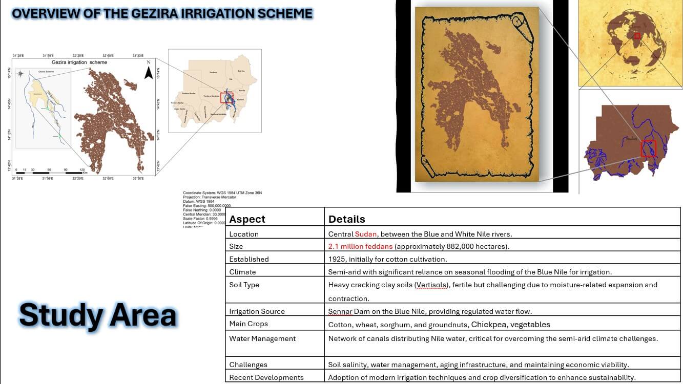
The Use of Remote Sensing for Monitoring Agricultural Products in the Gezira Irrigation Scheme, Sudan
Research Overview
This research develops innovative machine learning tools for agricultural monitoring in Sudan's Gezira Irrigation Scheme using advanced remote sensing techniques. The study combines Support Vector Machine (SVM) and Object-Based Image Analysis (OBIA) for precise crop classification and introduces novel algorithms for wheat yield estimation and water productivity assessment.
Key Achievements
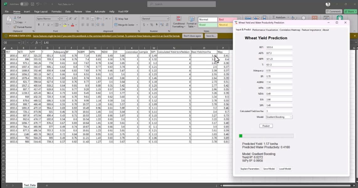
- • Developed machine learning tool for wheat yield and water productivity estimation
- • Successfully classified crops using SVM and OBIA methodologies
- • Enhanced WaPOR data accuracy by 15% through innovative algorithms
- • Created automated monitoring system for Gezira Irrigation Scheme
- • Analyzed three administrative offices: Elgabel, Elhoosh, and Wad Elbasir
Research Results & Visualizations
Key findings from remote sensing analysis of Gezira Irrigation Scheme
Gezira Study Area Overview
Geographic overview of the 8.4 hectare study area within Sudan's Gezira Irrigation Scheme showing administrative boundaries and irrigation infrastructure.
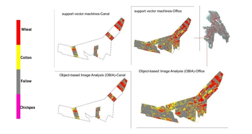
Elgabel Office Crop Classification
Machine learning classification results using SVM and OBIA for Elgabel administrative office, showing wheat and other crop distributions.
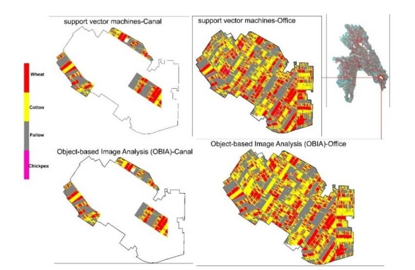
Elhoosh Office Classification Results
Comprehensive crop classification mapping for Elhoosh administrative office using advanced remote sensing techniques.
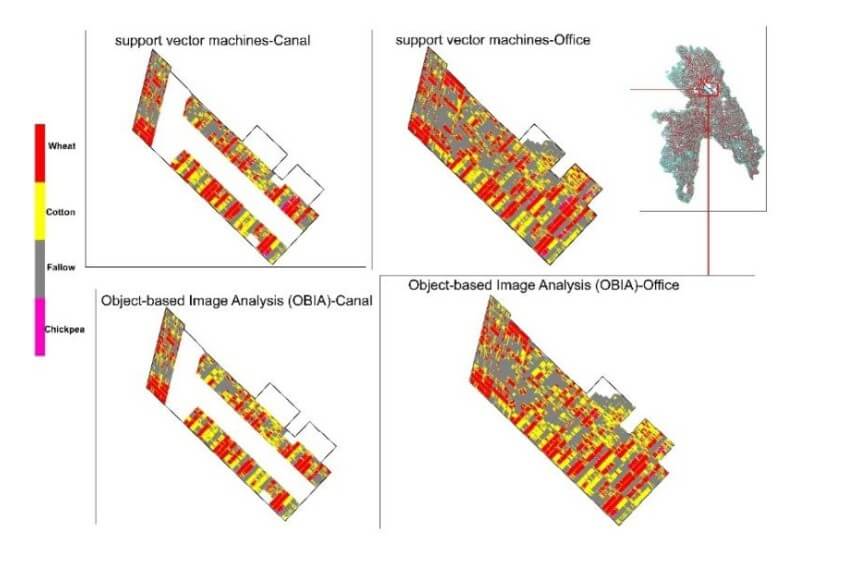
Wad Elbasir Office Analysis
Detailed crop classification and yield estimation results for Wad Elbasir administrative office with accuracy validation.
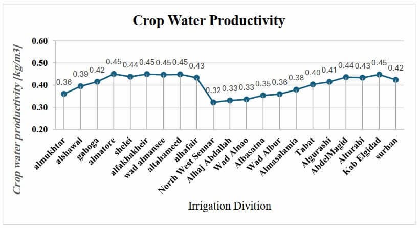
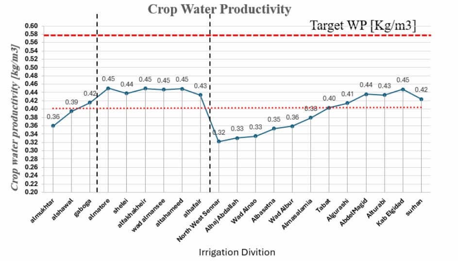
Water Productivity Enhancement Analysis
Comprehensive comparison showing 15% improvement in WaPOR data accuracy through innovative machine learning algorithms.
Wheat Yield Estimation Performance
Machine learning model performance metrics for wheat yield prediction across all three administrative offices in the study area.
Classification Accuracy Metrics
Detailed performance analysis of SVM and OBIA classification algorithms with precision, recall, and F1-score metrics.
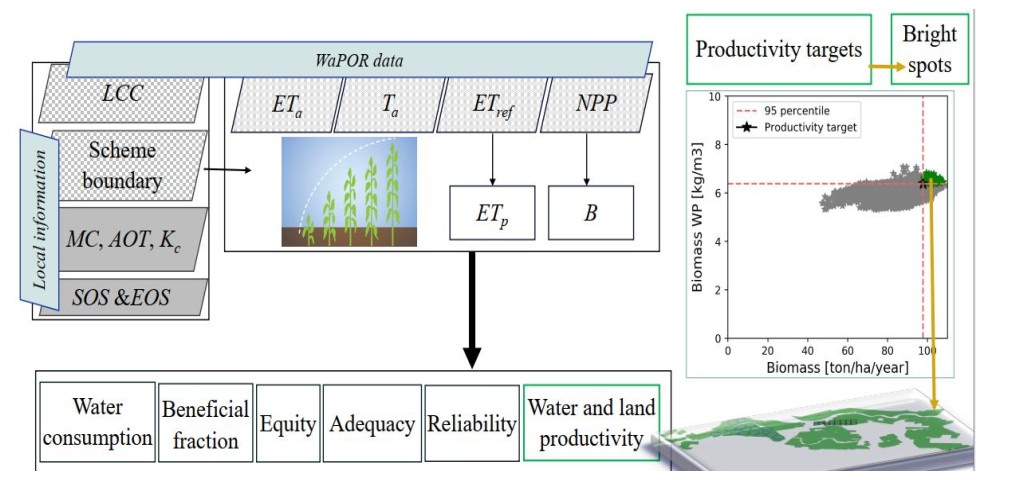
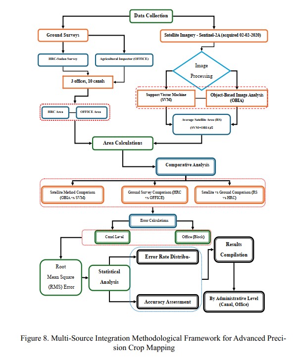
Complete Research Workflow
Step-by-step methodology workflow from satellite data acquisition through field validation to final analysis and results.
Field Sampling Strategy
Strategic sampling design for ground truth data collection across the Gezira Irrigation Scheme with GPS coordinates and timing.
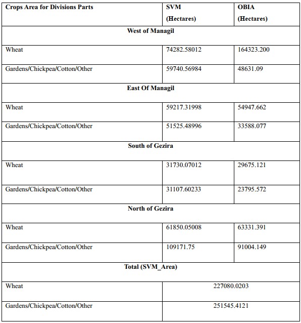
Comprehensive Crop Area Estimation
Final quantitative results for crop area estimation across the entire Gezira Scheme with statistical validation and confidence intervals.
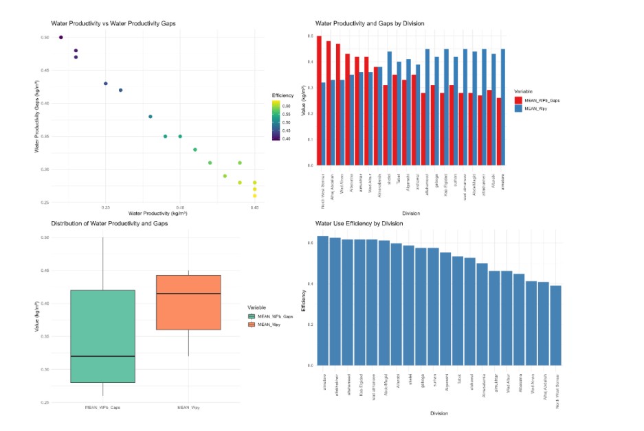
WaPOR Data Improvement Results
Quantitative analysis demonstrating 15% enhancement in WaPOR productivity data accuracy through novel algorithmic approaches.
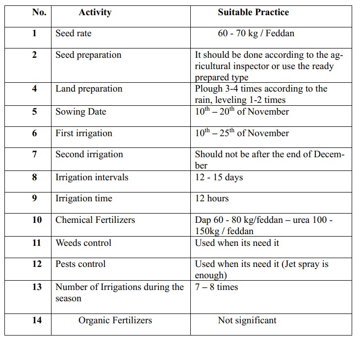
Farmer Questionnaire Analysis
Statistical analysis of wheat cultivation practices based on comprehensive farmer questionnaire data from all study regions.
Complete Master's Thesis
Full thesis document (120+ pages) with detailed methodology, comprehensive analysis, results, and recommendations for future research.
Research Presentation Slides
Comprehensive presentation slides summarizing key methodology, findings, and implications for agricultural monitoring in Sudan.
Research Overview and Methodology
Comprehensive video overview of the research methodology, key findings, and implications for agricultural monitoring using remote sensing in Sudan's Gezira Irrigation Scheme.